IslayBlog.com -> 2010 ->

Diciadain, 15/Sep/2010
Islay on old maps in the NLS

Sorry it's a bit late again. I spent most of the evening looking around old maps of Islay in the maps collection of the National Library of Scotland. A good year ago I blogged about Islay on Old Ordnance Survey Maps from the NLS, today I've looked at three other maps with sometimes interesting features on Islay and Jura. Signs of things to come as well as reminders of things now long gone. The three maps I looked at this evening are:
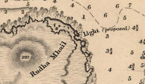
The first map is the Sound of Islay - Admiralty Charts of Scotland, 1795-1904, this specific sheet was surveyed 1852-3 and published 1856. The snippet above is from this map, it shows the north east corner of Islay, less a landmark now familiar to many: Rhuvaal Lighthouse. If you move south down the Sound of Islay you will come to Bunnahabhain Bay. No mention of Bunnahabhain distillery though, simple reason that it wasn't built until 1881. Slightly further south Caol Ila is listed, as it was founded in 1846
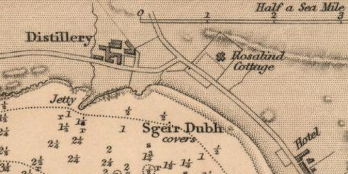
The second map is from the same series, it is Islay, Jura, Colonsay &c. - Admiralty Charts of Scotland, 1795-1904 (I have no idea what the &c. stands for though, any ideas?). This sheet was surveyed 1849-55, the inset of Port Ellen seems to have been surveyed in 1852. This inset also shows a distillery well known among whisky lovers (built in the 1820s), but now long gone:

The third and last map for today is titled Islay - Bartholomew Survey Atlas of Scotland, 1912. The distillery at Bunnahabhain can now be found on the map, although it is at ‘Bonahaven Bay’, Rhuvaal Lighthouse is also shown. Port Ellen distillery is also mentioned, after all it still had 70 years to go back then. There are also many ‘roads’ shown on the map which today are at best rough farm tracks, others footpaths and mountain bike tracks. Examples include the road to Gortantaoid, the road once connecting Kilchoman and Kilchiaran directly and the road between Lossit and Octafad.
I hope you'll enjoy exploring these maps, a lot of interesting things to discover here again. You can zoom in quite a bit in them and then navigate around by just dragging the map with the cursor.
There are a few more interesting maps in the collection, hopefully more about Islay on those some other time…
Update: I was wondering what &c. stands for. Thanks to Andrew Campbell from Islay I have now found out the answer: It is an old fashioned way to abbreviate et cetera, what we would now write etc.
Share ‘Islay on old maps in the NLS’: Tweet
Advertising
Navigation
[Previous entry: "Motorbike Journey to Kilchoman Distillery, Islay"] [Home] [Next entry: "Islay Lifeboat in Action Videos"]