IslayBlog.com -> 2010 ->

Diluain, 03/May/2010
Islay's Western Neighbour
To three sides it is fairly straightforward to determine Islay's neighbours: To the north is Colonsay, to the east are Jura, Gigha and Kintyre and to the south is Rathlin and Northern Ireland. But what is actually to the west of Islay? Of course there's a lot of Atlantic. And what else? One of the standard answers is ‘next stop America’, but where?
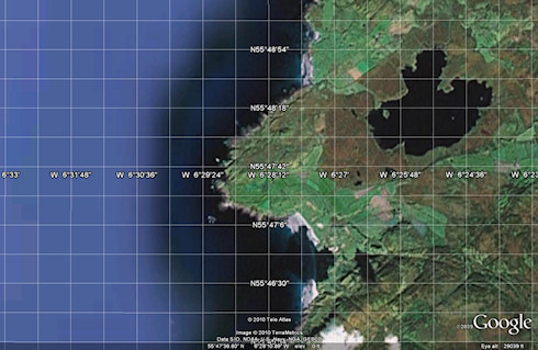
Let's go to Machir Bay or Saligo Bay and see where we would end up if we were swept out to sea and headed straight west. To do this I started Google Earth and zoomed in on the west coast of Islay:

According to this Machir Bay is at approximately N55°47'6'' while Saligo Bay is somewhere around N55°48'30''. Let the journey begin: For a while we can see the Irish coast towards the south (assuming we have clear weather). At some point we pass one of the sites of Operation Deadlight (Operation Deadlight Map), not that there's much to see (I'm assuming we're travelling above water). Then water, water, water, more water, more water and some more water. Until we finally reach land again.

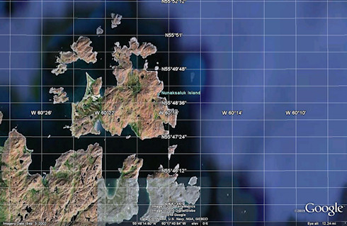
The place we have arrived at is called ‘Nunaksaluk Island’, in the Labrador Sea, east of the Davis Inlet in Newfoundland and Labrador, Canada. It seems rather remote, as far as I can tell it is uninhabited. There don't seem to be many pictures of the area available online, so far I've found Harrigan Harbour, Labrador (I believe at the south of Nunaksaluk Island). It seems to have a lighthouse, Cape Harrigan Light in the north east.
That's about it, all I've been able to find out about Islay's western neighbour. Probably best not to be swept out to sea …
Twitter about ‘Islay's Western Neighbour’
Advertising
Navigation
[Previous entry: "Islay Blogging Roundup #120"] [Home] [Next entry: "Cool Islay Windsurfing Video"]