IslayBlog.com -> 2010 ->

Diciadain, 05/May/2010
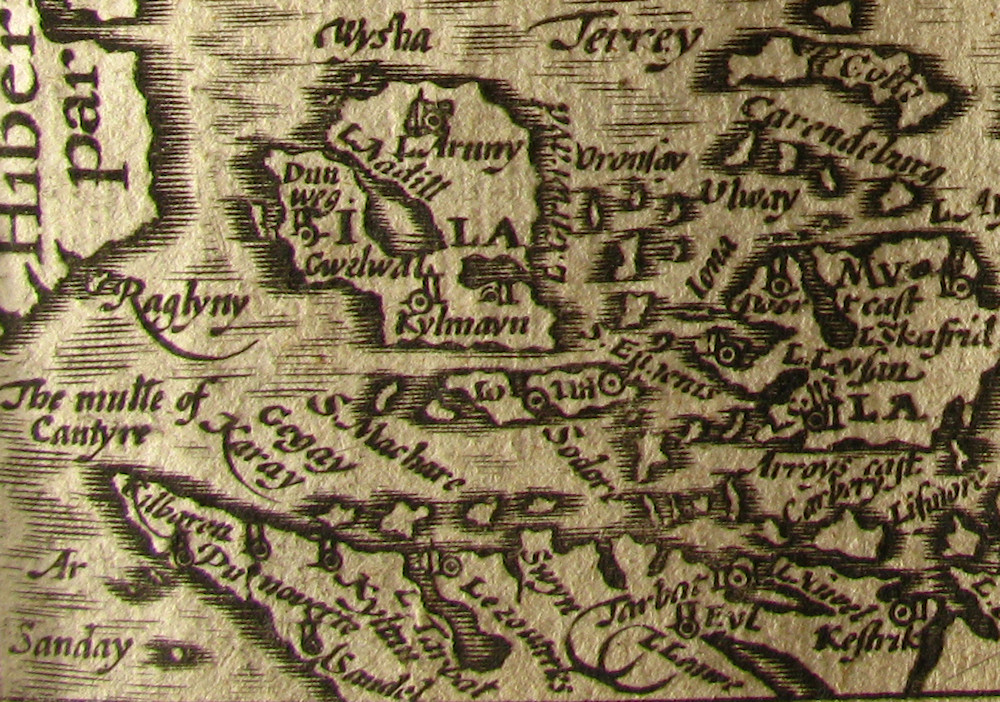
Islay on Map from 1620
Old maps are great window into the past. Back in 2007 I posted Islay, Jura and Colonsay on a Very Old Map, showing old maps from what we think the 18th century. Recently I came across another map taking us back another century, to 1620. Flickr user seriykotik1970 (a Brit living in Moscow) uploaded a set England Wales, Scotland and Ireland Described which includes a map of the Hebrides. Here's a crop with Islay:

The full original of the map is available at HEBRRIDES INSULAE que et Haebudes Beda Mevanias vocat by seriykotik1970. As he points out the orientation of the map is different to what we're used to, south is on the left while north is on the right. For a more familiar view turn the map by 90° anti-clockwise.
On the top corner is the north of Ireland with Rathlin (Raglyny), next to it is Islay (Ila). Some of the place names I can figure out: L.Nadill is Loch Indaal, Dunweg is Dunyvaig (Castle) and I guess Kylmayn/Kylmavn (sp?) is Kildalton. But what is L.Aruny (sp?) on the Rinns/Rhinns?
Jura almost disappears just below and right of Islay (at least that's what I think is Jura). At the bottom you can see Kintyre (with ‘The mulle of Cantyre’) and mainland Argyll. The larger island on the right is Mull, Coll in the top right corner. Oronsay is shown (just to the right of Islay), while Colonsay is omitted. I guess that's due to the priory on Oronsay?
Any other observations or comments from you?
Twitter about ‘Islay on Map from 1620’
Advertising
Navigation
[Previous entry: "Cool Islay Windsurfing Video"] [Home] [Next entry: "Another Landing on Islay Video"]